
- Visitor centre
- The Geopark Map
- Geology walking trails
- Roadside Geological route
- 1 Landscapes of yesterday, landscapes of today (Eripol)
- 2 A turbulent history (Boltaña Castle)
- 3 An ocean of rocks
- 4 Fossils and coins (Jánovas Narrow Pass)
- 5 A geological race (Broto)
- 6 The legacy of ice. Linás de Broto
- 7 Cinca River Delta (Morillo de Tou)
- 8 A channel under the sea (Morillo de Tou)
- 9 Braided rivers (La Serreta de Aínsa)
- 10 Añisclo Anticline formation (Road from Laspuña to El Pueyo de Araguás)
- 11 The Origins of the Peña Montañesa (Road from Escalona to Buerba)
- 12 The end of a geological Age (Bestué)
- 13 The most ancient rocks in Sobrarbe (Plan)
- Geological routes on muntain bike
- Geo-mining Trail
- The Sorrosal Cascade
- Geoconservation , everyone´s responsibility
- Megalithic Routes of the Geopark
- Patrimonio Mundial
- Ordesa-Viñamala Biosphere Reserve
- Didactic resources
- Areas of geological interest
- Sobrarbe Museum of Paleontology
- Locally sourced Sobrarbe produce
- Friends of the Geopark
7 Cinca River Delta (Morillo de Tou)
The language of rocks (Morillo de Tou)
Localización: Camino que desciende al pantano de Mediano desde el pueblo de Morillo de Tou.
Coordenadas . 265884 4695595 31 N
Textos Esperanza Fernández (Geopage)
It is often said that the layers of rock which form part of our landscapes are like the pages of a book chronicling the history of the Earth, telling story which is inscribed on the rocks in a language that geologists are learning to decipher. Many of the clues to this language can be found from observing places where processes are occurring now which will lead, in a geological future, to the formation of rocks. One such place is the Mediano Reservoir.
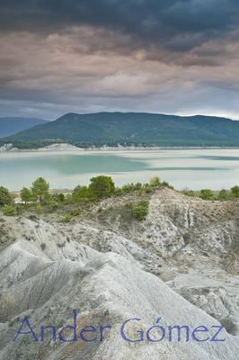
Embalse de Mediano. Fotografía: Ander Gómez.
Like any other river, the Cinca collects and transports water and various types of sediment, including solids (gravel, sand, clay and organic debris) and dissolved minerals (carbonates, nitrates, Ca and Mg ions, etc.). When the river reaches the reservoir, its capacity to transport the sediments is reduced and they are deposited in a particular order: the heaviest particles are deposited first and closest to where the river flows into the water contained in the reservoir, while the lightest particles and dissolved ions usually settle later and at a greater distance from the mouth.
The rise and fall of the water level, the water received from heavy rainfall (also laden with sediments), drought, the creatures that inhabit the reservoir or move about on the bottom...all these leave their traces in marks known as sedimentary structures. These structures are sometimes preserved when the sediment is transformed into rock, and they provide information on various events which occurred in the original environment where the rock began to form.
Some common sedimentary structures that can be easily identified in the Mediano Reservoir are as follows.
Horizontal layers
The sediments are deposited in layers called strata. Each stratum indicates an episode of sediment deposition. These are always deposited horizontally, one above the other, and the oldest layers are also the lowest.
Consequently, when we find non-horizontal strata, this tells us that the rocks have been subjected to some kind of geological phenomenon which has changed their original orientation.

Capas horizontales en el Embalse de Mediano. Fotografía: Esperanza Fernández
Mud cracks
Wet, muddy sediment tends to crack as it dries, forming polygonal cracks. Therefore, these cracks in rocks indicate an episode of desiccation at the site where the original sediment was deposited.
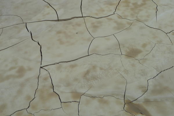
Grietas de desecación en el Embalse de Mediano. Fotografía: Esperanza Fernández
Ripple marks
These are wavy lines in the sediment that were produced by the action of water or wind currents, which moved the particles on the bottom.
The shape, symmetry and space between the ridges indicate the kind of current that generated the ripples. Rocks with ripple marks are very common in the Sobrarbe district. Most of them were formed when sands were deposited by turbidity currents in deep marine environments.

Rizaduras por corriente de agua en el Embalse de Mediano. Fotografía: Esperanza Fernández.
Bioturbation
The creatures inhabiting the depths, or those that crossed water-soaked areas, can leave their footprints. When these fossilise, they are called trace fossils and provide information on the behaviour of the living beings that inhabited the Earth in the past. In the Sobrarbe district, bioturbation caused by invertebrate organisms living on deep sea beds is very abundant.

Huellas de cabra en el fango húmedo del Embalse de Mediano. Fotografía: Esperanza Fernández

Huellas de perro en la arena húmeda del Embalse de Mediano. Fotografía: Ander Gómez
Did you know that .?
These structures are sometimes preserved when the sediment is transformed into rock, and they provide information on various events which ocurred in the original environment where the rock began to form.
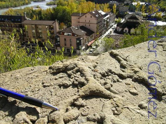
Bioturbaciones fósiles (en este caso, galerías de búsqueda de comida en el interior de la arena) en una roca empleada en la construcción en la localidad de Aínsa. Fotografías: Ander Gómez..

Fotografías: Ander Gómez..

Bioturbación realizada en el sedimento por un organismo sin identificar que se desplazaba sobre un antiguo fondo marino. Hoy se encuentra en una losa del suelo, en los alrededores de la Iglesia de Guaso. Fotografía: Esperanza Fernández
Recomentations in your visit to Sobrarbe-Pirineos Geopark
- Safe visits, unforgettable experiences. There are companies who collaborate with the Geopark where you can hire specialized guides to make your tour a unique and safe experience.
- Respect the geological outcrops. Do not break off samples of rock, mineral or fossils; anly take the loose pieces
Avda. Ordesa 79. 22340 Boltaña. Huesca. 974 518 025. geoparque@geoparquepirineos.com