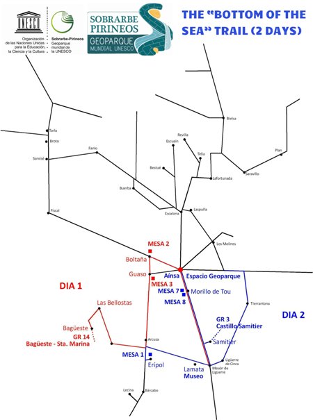
The "bottom of the sea" trail


COLLABORATING ENTITIES OF THE GEOPARK: on your trip to the Unesco Sobrarbe-Pyrenees World Geopark look for them and enjoy their welcome and services.
Day 1
ROUTE: Boltaña - Guaso - Las Bellostas - Bagüeste - Santa Marina hermitage
TYPE OF ROUTE: A linear route by car between Boltaña and/or Aínsa and Las Bellostas (there and back on the same road).
Includes a visit to:
- Table 3: An ocean of rocks, in Guaso.
- Geo-Route on foot GR 14 Secrets of the Guara Mountains. Las Bellostas-Santa Marina.
STARTING POINT: From Boltaña take the A-2205 from the Monasterio Hotel, towards Guaso and Arcusa. From Aínsa, take the A-2205 from the Meson de Ainsa Hotel, towards Guaso and Arcusa.
1st STOP: Guaso
Guaso's unusual layout sets it apart from other villages because its houses and neighbourhoods are spread out on the sides of a hill at the top of which sits its Romanesque parish church and the "Esconjuradero". It's also the ideal spot from which to take a geological look at most of the Sobrarbe-Pirineos Geopark.
Have a look at Information Table 3. "An ocean of rocks". Geo-Route panel at the side of the road.

Views from Guaso.

Guaso's church.

Guaso "Esconjuradero".
2nd STOP: Sarsa de Surta and Las Bellostas
There are several stops you can make along the way, for example at the villages of Sarsa de Surta and Las Bellostas. Here you can take in dramatic landscapes and curious architecture as you gaze towards the northerly peaks of the Ordesa and Monte Perdido National Park, from this abandoned territory so little known by most of the Sobrarbe-Pirineos Geoparque's visitors.

Sarsa de Surta.

Las Bellostas.
3rd STOP: The "Las Bellostas to Bagüeste" route
A walk along the Geo-route GR 14 Secrets of the Guara Mountains. Las Bellostas-Santa Marina.
- Route: Las Bellostas-Bagüeste. From here we suggest you go up to Santa Marina or, as an option, you can go as far as the Saltador de las Lañas waterfall (upper Mascún) and return to Las Bellostas taking a different route.
- Type of route: Circular with the option of turning off as far as the Saltador de las Lañas waterfall.
- Difficulty level: Medium. The path is not difficult but it is long.
- Duration: 5.5 hours (there and back) if you go up to Santa Marina; 2 hours more (there and back) if you go as far as the Lañas waterfall.
- Length: 13 kilometres in the first option.
- Gradient: 850 metres on the climb up (if you go as far as Santa Marina) and the same coming down.
- Geo-Route description and geological information: GR 14 Secrets of the Guara Mountains. Las Bellostas-Santa Marina.

Balced River.
Day 2
ROUTE: Aínsa - Morillo de Tou - Samitier Castle - Lamata - Erípol
TYPE OF ROUTE: A linear route by car from Aínsa to Erípol. You can either come back on the same road or go via Arcusa and Guaso.
Includes visits to the following places of geological interest:
- GR1 Geopark Interpretation Centre, in Aínsa Castle.
- Table 7.Cinca River Delta, the language of rocks and Table 8. A channel under the sea, castles on vantage points, in Morillo de Tou.
- Geo-Route GR 3 Geology: A bird's eye view.
- Sobrarbe Museum of Paleontology.
- Table 1. Landscapes of yesterday, landscapes of today (Erípol).
- STARTING POINT: Aínsa.

1st STOP: Sobrarbe Geopark Space, in Aínsa Castle
To get a general picture of the Sobrarbe Geopark, we recommend a visit to the Geopark Visitor Centre in Ainsa Castle. You can download the GR1 Geopark Interpretation Centre Geo-Route in advance from the Geopark Website.

Sobrarbe Geopark Space.
2nd STOP: Morillo de Tou
Take the A-138 south from Ainsa towards Barbastro. Stop in the first village, Morillo de Tou, and have a look at the geological information tables 7 and 8.
- Table 7.Cinca River Delta, the language of rocks
- Table 8. A channel under the sea, castles on vantage points

Morillo de Tou church.
3rd STOP: Geology: A bird's eye view. Samitier castle and hermitages
Continue along the main road until you reach the village of Samitier, where you can park the car and follow signs for the GR 3 Geology: A bird's eye view. Samitier castle and hermitages Geo-Route.
- Route: Samitier-Samitier Castle and Church of Saint Emeterio and Saint Celedonio
- Type of route: linear (return along the same route).
- Difficulty level: Low. The route is easy as it runs along a good path. The passage from the chapel to the castle (access to Stop 4) is not recommended for people with a fear of heights, although it does not involve any technical difficulty.
- Duration: 2 hours out and 1.5 hours return.
- Length: 7 kilometres (return).
- Gradient: 250 metre climb (only on the way out).
- Geo-Route description and geological information: GR 3 Geology: A bird's eye view. Samitier castle and hermitages.

View of the chapel and the end of the Entremon.
4th STOP: Sobrarbe Museum of Paleontology
More information: Sobrarbe Museum of Paleontology.
5th STOP: Erípol
The day ends in Erípol, a small village with defensive origins from the time of the "Reconquista". From here you'll get one of the widest panoramic views in the south of Sobrarbe.
Walk up to Table 1. Landscapes of yesterday, landscapes of today.

Table 1. Landscapes of yesterday, landscapes of today.
Avda. Ordesa 79. 22340 Boltaña. Huesca. 974 518 025. geoparque@geoparquepirineos.com
